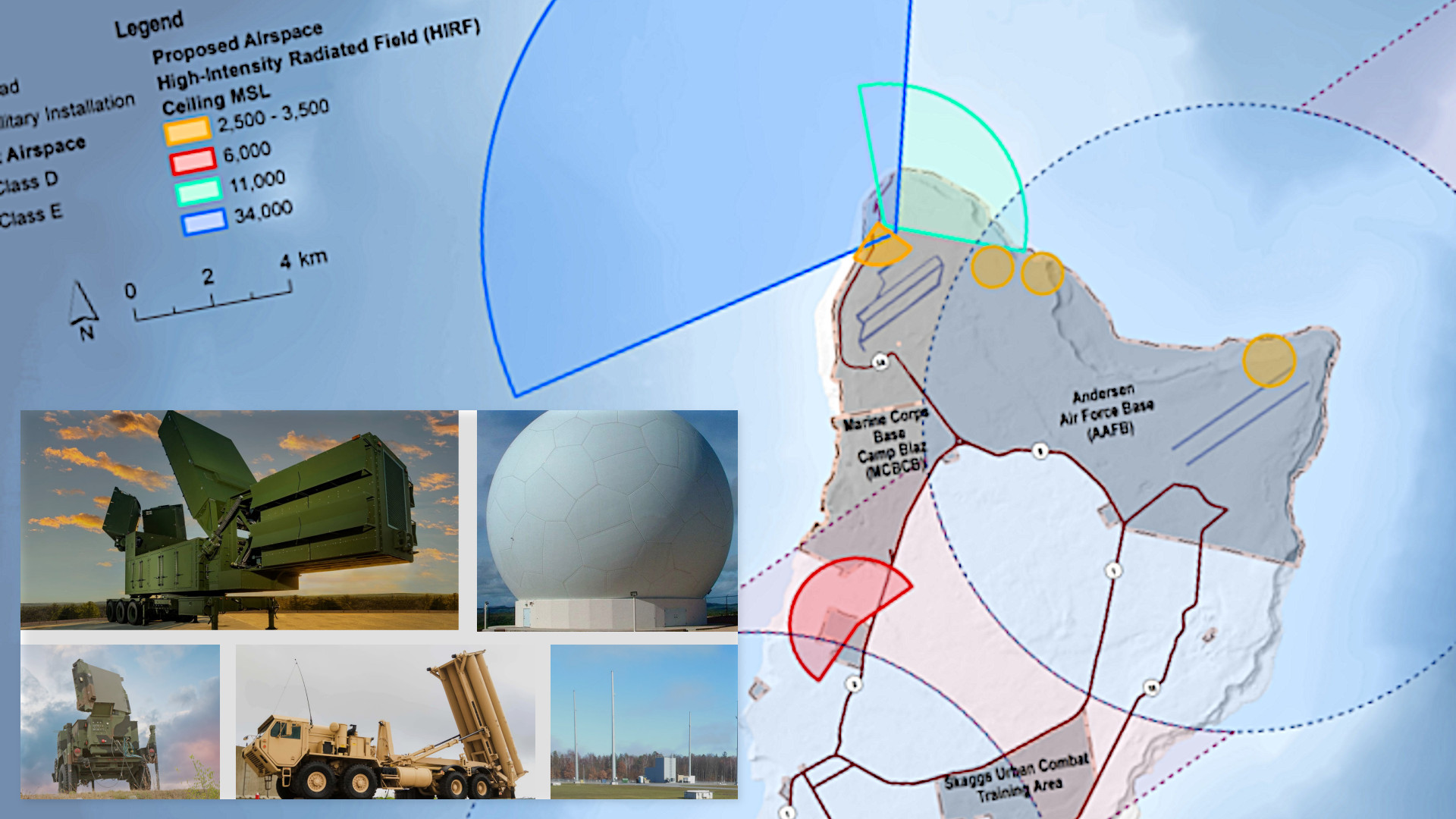
Guam is set to gain as many as 20 new air defense sites packed with surface-to-air interceptors, radars, and more as part of a massive defensive upgrade plan. Overall, the island looks set to become the most densely protected place anywhere on the planet.
Documents the U.S. military has released discussing the potential impacts on day-to-day life on Guam from the new air and missile defenses have offered a new look at the scale and scope of the project. A total of 20 separate sites are currently under consideration to host surface-to-air interceptors, radars, and other elements of the planned Enhanced Integrated Air and Missile Defense (EIAMD) system. In addition to changes on the ground, the system is expected to come along with new airspace restrictions, particularly around radar sites that will be in constant operation and present potential electromagnetic interference hazards.
The U.S. military held multiple so-called “public scoping meetings” on Guam earlier this month to provide information about the planned EIAMD system to residents and solicit feedback. Members of the public have until August 18 to submit further comments and criticisms about the project and its potential environmental impacts.

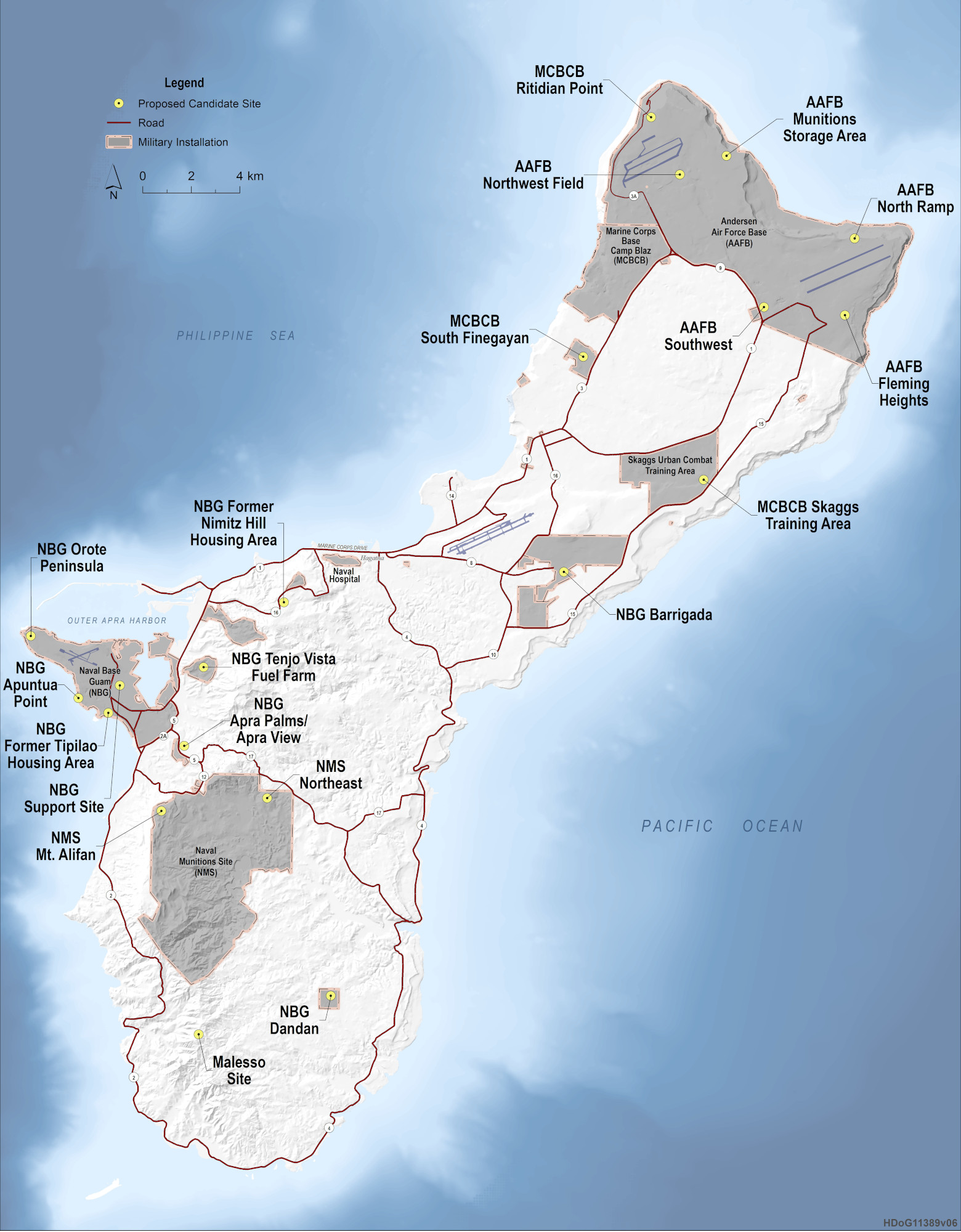
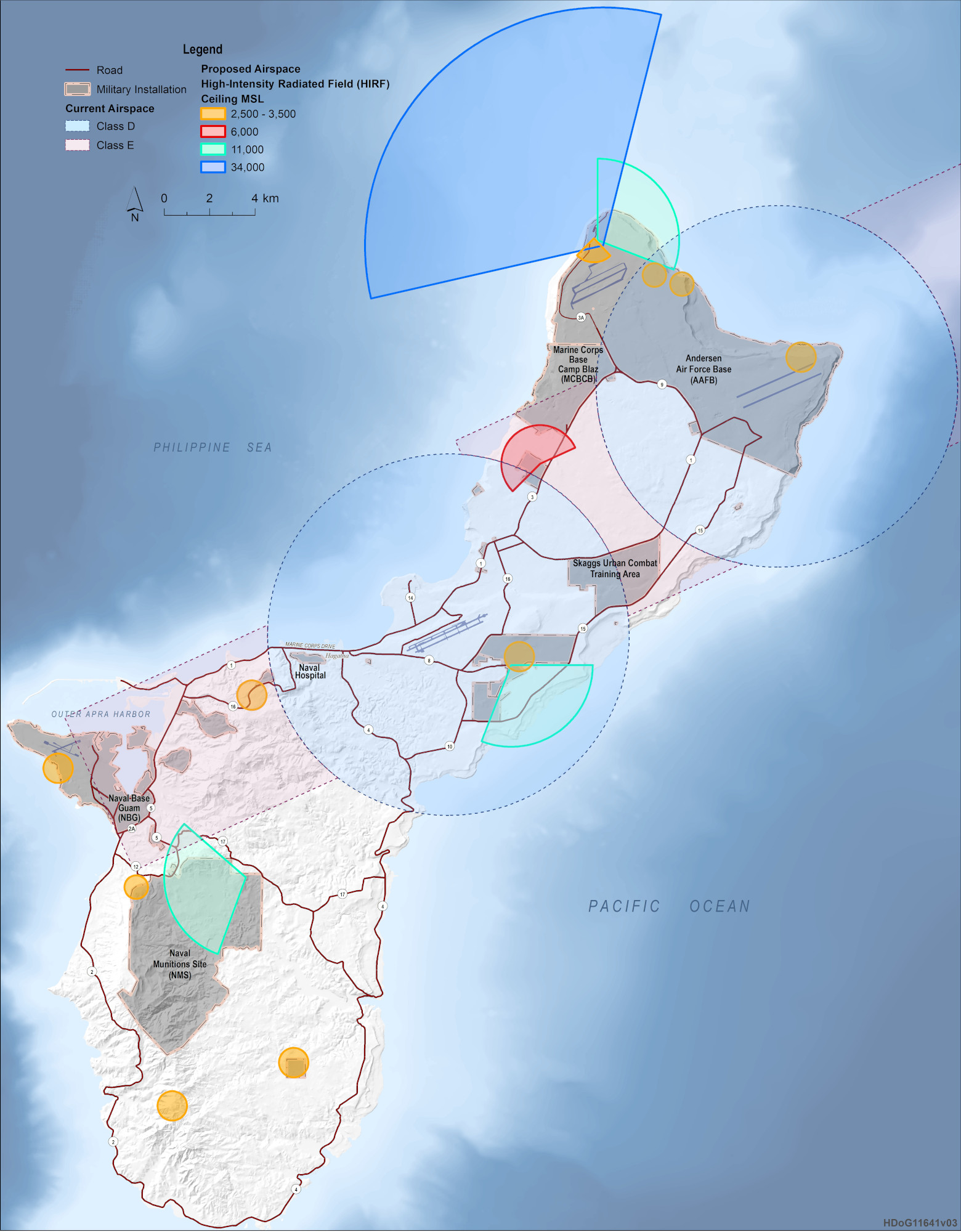
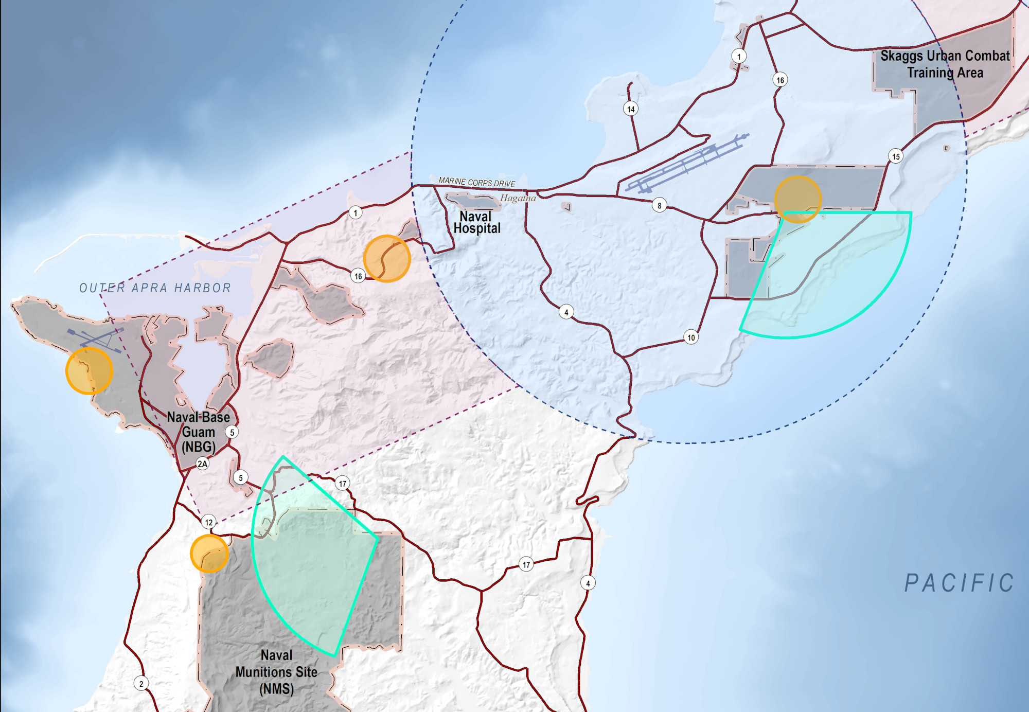
Included in the information that the U.S. military provided was a map showing the location of various candidate sites for hosting different elements of the EIAMD system and another one showing radar arcs and restricted airspace zones that are set to come along with it.
“The missile defense system would be able to defend Guam a full 360 degrees around the entirety of the island. The 360-degree capability would be achieved by distributing/placing system components at multiple locations around the island,” a block of text accompanying the candidate site map explains. “Site selection is evolving and additional sites may be considered.”
“If the Proposed Action is implemented, MDA [Missile Defense Agency] and the Army would construct the Enhanced Integrated Air and Missile Defense (EIAMD) and it would operate continuously,” additional text providing context for the radar/airspace map says. “FAA [the Federal Aviation Administration] would take actions related to restricting the flight of aircraft in airspace where high-intensity radiated fields would exceed FAA certification standards for aircraft electrical and electronic systems.”
“Implementation of the Proposed Action would result in the establishment of new Restricted Areas and change federal airways and instrument flight procedures to accommodate new Restricted Areas,” it adds. “MDA and the Army would not begin continuous operation of the EIAMD system until FAA actions related to restricting the flight of aircraft are complete.”
Particular concerns about the impacts on Guam from the installation of the myriad new radars that are part of the EIAMD have come up before and the U.S. military has previously acknowledged this as a topic area requiring special attention.
“So, when you think about transporting yourself to some other location, whether it’s in the United States or abroad, you have to worry about explosive arcs… you have to worry about the electromagnetic interference of the radars,” now-retired Vice Adm. Jon Hill, then head of MDA, said last year. “So, one of the first conflicts we had, it’s been in the press already, but I think it’s resolved, is if you’re going to build a hospital on this site, and you have a radar over here, is it okay to put radar energy through that site where you bring MEDEVAC [medical evacuation] helicopters in? The answer’s no.”
As currently planned, EIAMD is a distributed and tiered ‘system of systems’ intended to provide 360-degree air and missile for Guam, as a whole, against various types of aerial threats. The island, which is a U.S. territory, is strategically located in the western Pacific and is home to major Air Force, Navy, and now Marine Corps bases. These would be among the top of the list of priority targets for an opponent during any future high-end conflict in the region, such as one against China.
A version of the Aegis Ashore system tailored to Guam’s unique geography and other requirements will be at the core of EIAMD. This is expected to look significantly different from U.S. Aegis Ashore sites currently in Romania and Poland, the latter of which is not yet operational, but is expected to be later this year. The U.S. military has a dedicated Aegis Ashore test site in Hawaii.
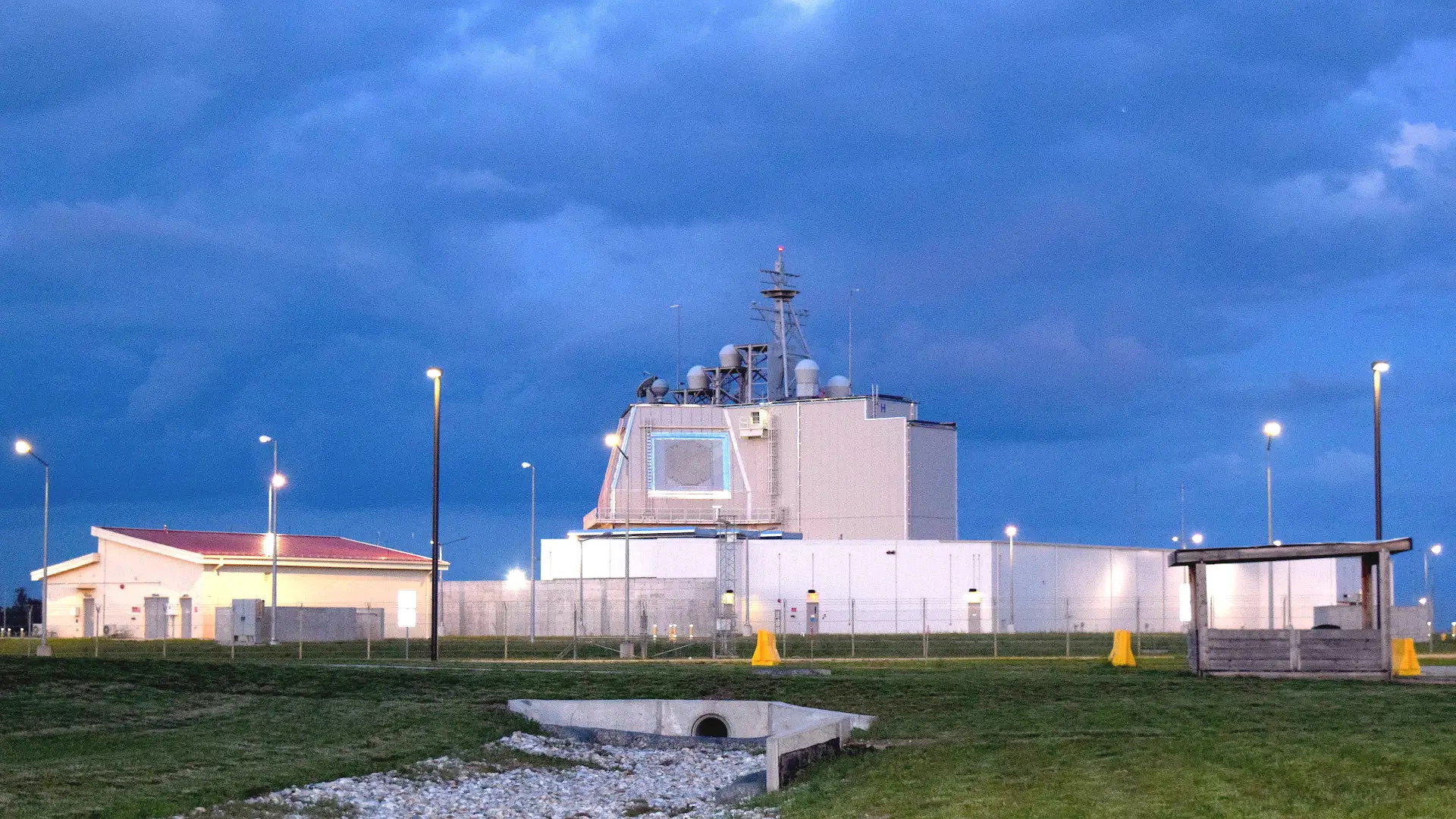
As originally designed, Aegis Ashore directly ported over various components, including the AN/SPY-1 radar and Mk 41 Vertical Launch System (VLS), from the Flight IIA Arleigh Burke class destroyer into a land-based configuration. The primary interceptors for the system have long been variants of the SM-3, including the Block IIA variant designed to be able to engage intercontinental ballistic missiles (ICBM) during the mid-course portion of their flight outside of the Earth’s atmosphere.

Thanks to the multi-purpose nature of the Mk 41 VLS, additional missiles, such as variants of the multi-purpose SM-6 and the now-in-development Glide Phase Interceptor (GPI), which is being designed to engage incoming hypersonic boost-glide vehicles, could be integrated into the system in the future.

The exact configuration of Guam’s Aegis Ashore system remains to be seen. However, the U.S. Missile Defense Agency has made clear in the past that it will be distributed to a far greater extent than its predecessors. There have been discussions in the past about installing certain components in hardened underground facilities or putting them on road-mobile ground platforms.
What is known now is that the higher-end tier of the EIAMD will also include at least four AN/TPY-6 radars. This design was previously known as the Homeland Defense Radar-Guam and leverages technology from Lockheed Martin’s Long Range Discrimination Radar (LRDR) now in place in Alaska.

The U.S. Army is planning to provide Terminal High Altitude Area Defense (THAAD) anti-ballistic missile systems, Patriot surface-to-air missile systems, Typhon Mid-Range Capability systems (which can fire SM-6 multi-purpose missiles, as well as Tomahawk cruise missiles), and Enduring Shield Indirect Fire Protection Systems, to provide lower layers of air and missile defense coverage.

THAAD, Patriot, and Typhons with SM-6 would offer options for engaging various types of ballistic and cruise missiles, as well as fixed-wing aircraft and other aerial threats. Enduring Shield, which will at least initially fire AIM-9X Sidewinder missiles, is designed to offer additional protection against cruise missiles, drones, and even artillery rockets. The War Zone has repeatedly highlighted the very real threat posed now by drones, including very low-end commercial types that can be readily weaponized, or used for surveillance or other malign purposes, pose to U.S. forces abroad and at home, including on Guam.
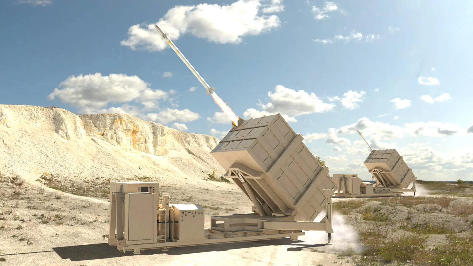
An Army THAAD battery has already been forward-deployed on Guam since 2013. The Army also deployed Iron Dome systems, comparable in form and function to Enduring Shield, as part of a test in 2021.

The Army’s contribution to the new EIAMD on Guam will also include at least three Lower Tier Air and Missile Defense Sensor (LTAMDS) radars, as well as multiple smaller Sentinel types, distributed around the island.

A command and control architecture that includes elements of the Navy’s Aegis Combat System and the Army’s Integrated Battle Command System (IBCS) will help tie all this together, allowing for a great deal of flexibility and general situational awareness. The networks will also help Guam’s defenders choose different interceptors and associated sensors, as well as fuze data to produce higher fidelity tracking and targeting data, to best respond to different types of incoming threats and do so faster and with greater accuracy.
Those networks will be able to feed in information from offboard sources, as well. This includes existing and future space-based sensing assets. Work is already progressing on the development of a new hypersonic weapon-focused tracking constellation that is expected to eventually include dozens of individual satellites.
As noted, exactly where EIAMD’s various components would be positioned has not been fully settled yet.
The radar/airspace map included in the public environmental impact information does show three prominent radar arcs emanating from an area near Ritidian Point at the northern end of Guam, Naval Base Guam’s (NBG) Barrigada site in the middle of the island, and a location within the Naval Munitions Site (NMS) in the south. It is possible these could reflect sites under consideration for some of the AN/TPY-6 or LTMADS radars.
A fourth and much larger arc is also shown projecting from Ritidian Point, which is now under the jurisdiction of the Marine Corps’ new Camp Blaz on Guam, which could point that being the planned location for the core of the island’s future Aegis Ashore system. There is also the possibility that this could reflect the existing AN/TPY-2 radar associated with the Army’s THAAD battery that is already in place at the northern end of the island.
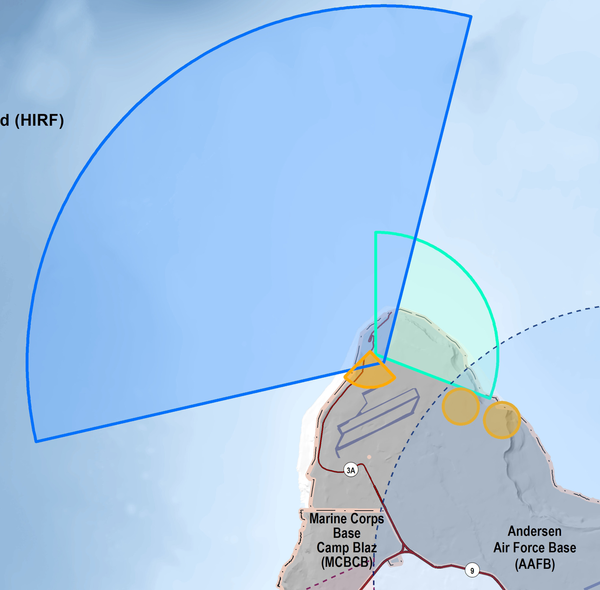
There are 11 other radar arcs marked on the map, which would seem to reflect the various expected lower-tier components of the complete EIAMDS.
The exact timeline for when all of the planned EIAMDS components will be installed is unclear. Officials have said in the past that they want at least some parts of the system to be in operation by 2026. At a conference earlier this week, Navy Rear Adm. Doug Williams, the acting director of MDA, said that there is a plan in place now to conduct an initial live-fire test, which would be of an SM-3 Block IIA missile from the Aegis Ashore site, on Guam in December 2024.
There are a number of potential hurdles that could delay the EIAMDS effort, including potential opposition from residents on Guam. The U.S. military will also need to secure sufficient funding across multiple years to pay for the various new air and missile defense systems for the island. The Missile Defense Agency and the Army together have requested nearly $1.44 billion just in the 2024 Fiscal Year to support this work, according to Defense News.
In addition, the U.S. Army recently highlighted challenges in recruiting for the service’s air defense branch during discussions about separate plans to increase the number of Patriot systems in its force structure in the coming years. Difficulties attracting individuals, even those who already serving, to join this particular part of the Army could have impacts beyond the Patriot community, which in turn could affect the EIAMDS timeline.
What is clear is that the U.S. military’s plans for significantly expanding air and missile defenses on Guam are continuing to solidify and, if they proceed as planned, look set to bring significant changes to Guam, both on the ground and in the air above the island.
Contact the author: joe@thedrive.com
