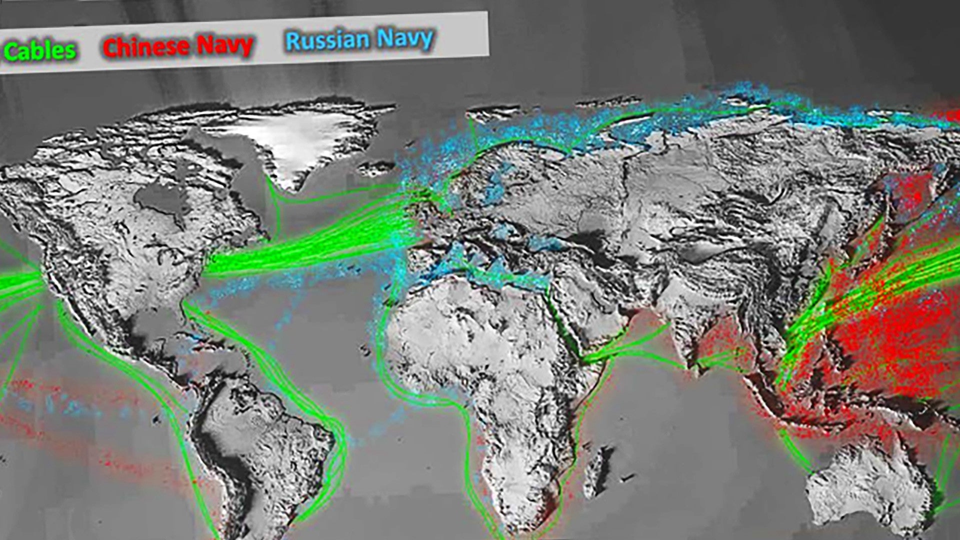
The Pentagon has released a map showing areas of increased Russian and Chinese naval activities, as well as the locations of major undersea cables, around the world as part of its most recent budget request for the 2021 Fiscal Year. This is perhaps the most granular detail on these subjects that the U.S. government has provided to date after years of warning about the threats that these patrols, especially by Russian submarines, pose to American national interests. Just last week, we reported that a senior U.S. Navy officer stated that Russian submarine sorties had become such an issue that the service no longer treats the East Coast of the United States as “uncontested” and would no longer view it as a guaranteed “safe haven” in a crisis.
The U.S. military released the annotated map in a 134-page overview report accompanying its 2021 Fiscal Year budget proposal. The graphic is part of a section describing new and emerging security concerns, especially with regards to so-called “great power competitors,” such as the Russians and the Chinese. The Trump Administration does not appear to have included any similar map in the documentation that went along with its previous budget requests for the 2018, 2019, or 2020 Fiscal Years.
“We continue to see increased reliance on the maritime system, with maritime traffic increasing four-fold over the last 2 decades; 90 percent of all global goods being shipped, and new trades routes opening to the north,” the document explains. “Almost the entire internet and trillions of dollars in trade are carried today on a largely unsecure network of undersea cables.”
“Overall, the maritime system is more heavily used, more stressed and more contested than ever before,” it continues.

Though the map does not say what time period it covers and or what types of naval vessels were necessarily present in specific locations and when, it does confirm that there has been notable Russian naval activity off the coast of the southeastern United States, as well as in the North Atlantic Ocean and Caribbean, in recent years. It also shows notable operations in Russia’s Arctic region, an area that is becoming increasingly strategically important.
Russian naval vessels also follow clear transit routes in the Atlantic, as well as the Pacific, according to the map. There is one main route between the waters off the coast of Portugal and Spain and the Southeastern United States and the Caribbean, not surprisingly mainly around Cuba, with branches that also run from the North Atlantic to the northern coast of South America and between the Gulf of Guinea in Africa and the northeast tip of Brazil.
What is perhaps most striking is the relative density of Russian naval activity around the United States, and even around Russia’s own shores, compared to that of Chinese maritime operations in the South China Sea and other areas of the Western Pacific. China also has a very active presence in the Chukchi Sea in the Arctic northwest of the Bering Strait, north of Russia’s Far East regions, according to the map. This, overall, is a clear reflection of the explosive growth in the size and capabilities of the People’s Liberation Army Navy, something The War Zone
has discussed on multiple occasions.
“Our global competitors continue to grow their naval forces, and they are expanding their areas of operations and collaboration with each other,” the budget overview report says. ” We simply have a lot more to protect from increasingly capable maritime adversaries who will present challenges to our economic security and indeed, our very way of life.”
This newly released map from the Pentagon gives us one of our first good looks at the scope and scale of these concerns, which are only likely to expand in the future.
Contact the author: joe@thedrive.com
