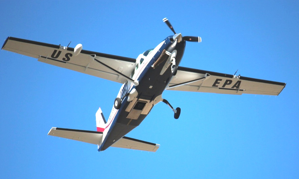
As federal, state, and local agencies continue to respond to the damage and flooding wrought by Hurricane Harvey in Texas, as well as neighboring Louisiana, one of the more contentious questions has been the danger posed to communities by heavily polluted sites within the disaster zone. As part of its response, the Environmental Protection Agency has deployed the unique Airborne Spectral Photometric Environmental Collection Technology surveillance aircraft, which can spot chemical and radiological material from the air, to help assess the situation.
More commonly known by the acronym ASPECT, contractor owned and operated system is configured to collect chemical and radiological information, as well as both color visual and infrared imagery. EPA has had it on call for more than a decade, sending it out in the past to either actively monitor disasters, including the Deepwater Horizon oil spill in 2010, or be ready in the event of an emergency during a major public event, such as multiple presidential inaugurations, Super Bowls, and other large gatherings.
“ASPECT is the nation’s only airborne real-time chemical and radiological detection, infrared and photographic imagery platform,” EPA says on its website. “ASPECT is available to assist local, national, and international agencies supporting hazardous substance response, radiological incidents, and situational awareness.”
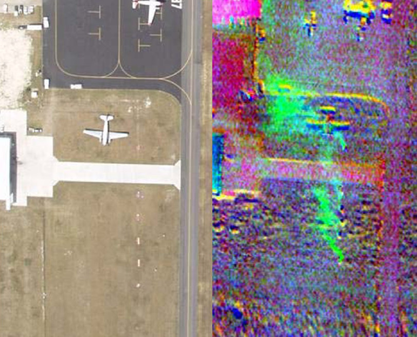
Similar to many military intelligence and reconnaissance aircraft, the APSECT aircraft carries a wide-angle mapping camera and an infrared line scanner that can create thermal imagery of the ground below as the plane flies along. Analysts can put the basic color images together form even larger maps of a specific area, well.

In addition, EPA’s surveillance aircraft has less common gamma ray and multi-spectral chemical spectrometers. This allows the crew to collect information about spreading hazards that may not be visible to the human eye. The chemical sensor can help determine what compounds are present and how densely they’re concentrated in the air. The Department of Energy also has aircraft for mapping radiological incidents, in particular a small fleet of Bell 412 helicopters specifically outfitted for the role. But these aircraft lack the ability to keep tabs on other toxic chemicals that may be airborne and they don’t have ASPECT’s multi-spectral imaging capabilities. From the EPA’s website:
“The National Nuclear Security Administration, part of the Department of Energy, does operate the Aerial Measuring System. However, this only collects radiological data in real time, while ASPECT provides a multi-sensor capability.”
Initially, the contractor used a twin engine Aero Commander 690, seen in the video below, to carry all of these systems. This eventually gave way to a simpler and cheaper to operate Cessna C208B Grand Cavaran, which is the present platform. As of April 2014, it cost EPA $1,500 per flight hour to operate the ASPECT Cessna.

Contractor Airborne ASPECT says it can have the plane up in the air from its home base near Dallas, Texas and on its way to a disaster are within an hour. Within nine hours, the aircraft can reach anywhere in the country. According to EPA, it only takes one phone call to the company to get the whole process started.
In or near an affected area, a team of scientists and other specialists set up a processing center on the ground to pore over the data. It only takes approximately five minutes for the crew of the aircraft to send the compressed information to this team via a satellite link.

Though EPA runs the ASPECT program, other agencies, including the National Guard, can request support from the aircraft through the Department of Homeland Security’s Interagency Remote Sensing Coordination Cell. According to a 2013 National Guard handbook on incident awareness and assessment, which the author previously obtained via the Freedom of Information Act, the plane’s capabilities could be useful in general after earthquakes, floods, tsunamis, tornadoes, volcanic eruptions, wildfires, and terror attacks, as well as hurricanes.
Already situated in Texas, ASPECT was quickly on the scene over Houston after Harvey hit. More importantly, it has given EPA a way to quickly inspect the toxic Houston-area zones, known as Superfund sites. The Comprehensive Environmental Response, Compensation, and Liability Act of 1980 designated these areas for cleanup as part of the Superfund program.
Texas is home to 66 Superfund sites, more than 40 of which were within Hurricane Harvey’s impact area, according to Buzzfeed News. There is no indication that any of these contain radioactive materials, so ASPECT is likely gathering information on potential chemical releases, as well as basic information about the state of the areas.
The Superfund areas in the site mainly contain waste from oil, gas, and other petrochemical related activities, as well as farming and ranching. As such, they can contain dangerous, toxic, and carcinogenic substances, such as sulfuric acid, heavy metals, now-banned pesticides, and polychlorinated biphenyls, better known as PCBs.
The concern is that the floodwaters could spread hazardous material and poison soil and groundwater for years to come. The storm and subsequent flooding had damaged more than a dozen, inundating the areas and limiting the ability of specialists to gain access on the ground.
ASPECT can monitor at least some of this danger from the air, though it would not be able to see pollution seeping down into ground below or necessarily be able to accurately discriminate pollutants mixing with the water above. The plane’s operations have been an important part of the EPA’s response to the disaster, which has received criticism from the press.
In a now controversial article, The Associated Press said it had managed to reach seven of the sites by boat, but had not received an explanation from EPA about why its inspectors had been unable to do the same. EPA said that its personnel would visit the sites on the ground once it was safe to do so and in the meantime would continue collecting data via ASPECT.
The piece noted that in 2012, under President Barack Obama, the environmental agency had completed a report warning about the risk to Superfund sites from flooding and rising sea levels related to climate change. President Donald Trump’s first budget request proposes a 30 percent cut to funding for the Superfund Program and his administration’s EPA Director Scott Pruitt has previously denied any scientific consensus on the existence on global climate change.

In response to the Associated Press story and subsequent reporting, the agency issued an unusually personalized public rebuke, suggesting that one of the article’s authors, Michael Biesecker, had deliberately left out numerous key details, including that it had worked with authorities in Texas to secure the Superfund sites before Harvey made landfall. The news wire issued its own statement afterwards, standing by work of its team and their on-the-ground reporting.
Regardless, neither the EPA nor independent observers may know the exact extent of the damage and resulting danger to nearby communities for some time. Despite previous warnings, no Superfund site has ever experienced this level of flooding, Buzzfeed reported, making it a completely unprecedented situation.
“We don’t have any precedent to figuring out what the cumulative effect is going to be on someone’s health,” Jennifer Horney, an associate professor of epidemiology at Texas A&M University who has led her own team to collect water and soil samples for analysis, told Buzzfeed. “They’re [residents of Houston] not going to get cancer tomorrow – they may get asthma in three months.”
In the meantime, it seems likely that the aircraft will continue to monitor the status of the Superfund sites, at least until the floodwaters begin to recede, which may take weeks. You can keep an eye out yourself for the ASPECT plane, which has the U.S. civil aviation registration N9738B, using online flight tracking sites.
Contact the author: joe@thedrive.com
